Geographic Information Systems (SIGs) are automated systems whose purpose is storing, analyze and manipulate geographic data. These systems help decision-making on various issues related to environmental and urban public monitoring policies. In addition, they are important in economic activities, such as agriculture and mineral extraction.
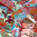
In this context, Remote Sensing Images (RSIs) is one of the most important sources of data, especially with regard to the creation of maps. This process and overall model as a classification problem with respect to a learning system with the user-supplied interest pattern and assign a class to the rest of the regions of the image. Due to recent advances in sensor technology, new challenges and opportunities have emerged in pattern recognition for remote sensing imaging. The Increasing accessibility of images with good resolution and spectral, temporal and / or spatial data has made possible deeper and detailed analyzes in several applications.
PATREO research focus in the development of pattern recognition strategies for remote sensing, which includes the following subtopics: spatial feature representation, spectral band selection/combination, time series analysis, segmentation, and multi-sensor data fusion.
Some relevant work in this topic are:
| K. Nogueira, O. A. B. Penatti and J. A. dos Santos. Towards better exploiting convolutional neural networks for remote sensing scene classification. Pattern Recognition, 61, 539-556, 2017. | |
| L. C. B. dos Santos, S. J. F. Guimarães, J. A. dos Santos. Efficient Unsupervised Band Selection Through Spectral Rhythms. IEEE Journal of Selected Topics in Signal Processing, vol.9, no.6, p.1016-1025, 2015. | |
| J. A. dos Santos, P-H. Gosselin, S. Phillip-Foliguet, R. da S. Torres, A. X. Falcão. Multiscale Classification of Remote Sensing Images. IEEE Transactions on Geoscience and Remote Sensing, v. 50, p. 3764-3775, 2012 |